There are more canals in Birmingham than in Venice, they say. Out of the past 160 miles, around 60 (100km) are no longer navigable, or have disappeared altogether.
Andy Tidy, canal enthusiast, blogger (Captain Ahab’s Watery Tales), and BCNS supporter, has created a brilliant series of videos where he explores the “lost canals”.
If you enjoy studying old maps and photos, wondering what may have happened to the places, where the lost canals and basins might have been, why they have been lost, and what’s in their place now, then you will just love the “Canal Hunter” videos.
With Andy’s kind permission, I have added the first two series to this website. Andy is working on another series, expected in 2020. Enjoy!
Introduction to the series
In his first video, Andy gives a brief introduction to the Birmingham Canal Navigations. His search for the remains of the “lost 60 miles” begins near his home base, featuring the Hay Head Branch (off the Daw End Canal), and Black Cock Bridge.
The Hay Head Arm
The Hay Head Arm (what remains of it) is now used by Longwood Boat Club. Andy explores the now lost part, and explains the industrial past of the area. It was an area of collieries and quarries, and brick makers.
The snippet below shows the Hay Head Arm in the legendary IWA “Blue Book” Birmingham Canal Navigations, and is reproduced with the kind permission of the IWA:

The same area, shown on Richard Dean’s Historical Map of the Birmingham Canals (reproduced with the kind permission of Richard Dean):
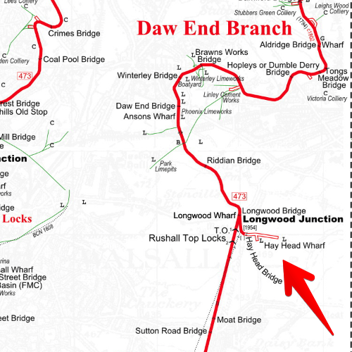
Hay Head Arm, on the Wyrley & Essington Daw End Branch
To put it into a modern context, here is the same area in the 2019 edition of Pearson’s Canal Companion, Stourport & Black Country Rings & Birmingham Canal Navigations, reproduced with the kind permission of Michael Pearson:

The Hay Head Branch in the 2019 Pearson’s Canal Companion for the BCN
The Hay Head Arm (what remains of it) is now used by Longwood Boat Club. Andy explores the now lost part, and explains the industrial past of the area. It was an area of collieries and quarries, and brick makers.
Black Cock Bridge
Black Cock Bridge is not on a lost canal. It’s “just” a bridge, but a bridge that can explain why so many canals disappeared.
The bridge is on the Daw End Branch of the Wyrley and Essington Canal. Andy explains the problems that came with extracting coal from under the canals that were built to transport it. Black Cock turns out to be a spectacular example. It’s close to the former Walsall Wood Colliery. Coal was extracted from under the ground, including the ground below the canal. Over time, the tunnels collapsed, the land sank deeper, and the canal had to be “lifted up” to stay level. The bridges had to be lifted with the canal, and Black Cock Bridge has holes for bottle jacks, to lift the bridge. It seems to have been, and perhaps is, a pretty “normal” thing to pump a bridge a bit higher!
Black Cock Bridge on Google StreetView
Whilst the canal was kept at the original level, the landscape around sunk significantly. The image below, from Google Street View, shows the approach to Black Cock Bridge – the bridge is on top of the hill! A click on the screenshot should take you directly to Street View, to explore how high the canal is now – or how low the surrounding landscape sank after the coal below was extracted.
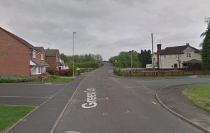
Green Lane approaching Black Cock Bridge
The snippet below shows Black Cock Bridge in the legendary IWA “Blue Book” Birmingham Canal Navigations, and is reproduced with the kind permission of the IWA:

Black Cock Bridge, on the Daw End Branch of the Wyrley and Essington Canal, in the IWA Blue Book
The same area, shown on Richard Dean’s Historical Map of the Birmingham Canals (reproduced with the kind permission of Richard Dean):
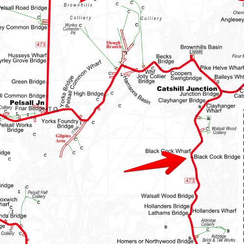
Black Cock Bridge, on the Wyrley & Essington Daw End Branch
To put it into a modern context, here is the same area in the 2019 edition of Pearson’s Canal Companion, Stourport & Black Country Rings & Birmingham Canal Navigations, reproduced with the kind permission of Michael Pearson:

Black Cock Bridge in the Pearson’s BCN Canal Companion
Without any further ado, here is the video:
There are more canals in Birmingham than in Venice, they say. Out of the past 160 miles, around 60 (100km) are no longer navigable, or have disappeared altogether.
Andy Tidy, canal enthusiast, blogger (Captain Ahab’s Watery Tales), and BCNS supporter, has created a brilliant series of videos where he explores the “lost canals”.
The project is getting bigger and bigger, covering more and more of the “lost 60 miles”, and it needs and deserves more space on this website.
If you enjoy studying old maps and photos, wondering what may have happened to the places, where the lost canals and basins might have been, why they have been lost, and what’s in their place now, then you will just love the “Canal Hunter” videos.
Series 1 – The lost sections of Brindley’s original canal from Birmingham to West Bromwich
1.2 Birmingham’s Lost Canal Basins
1.3 The Lost Loops of the Birmingham Canal Navigations
1.4 The Smethwick Summits
1.5 The Ridgacre Branch
1.6 The Balls Hill Branch Canal
1.7 Canal Hunter Resource Pack
Series 2 – The abandoned sections around the extended Birmingham Canal to Wolverhampton
2.1 The Titford Branch Canals
2.2 Oldbury and the Chemical Arm
2.3 The Toll End Communications Canal
2.4 The Wednesbury Oak Loop
2.5 The Lost Locks of Bradley
2.6 The Lost Canal Basins of Wolverhampton
2.7 Lost Canals around the Wolverhampton 21
Series 3 – The Wyrley and Essington Canal
The Wyrley and Essington wasn’t a planned extension of the BCN, it was built later and to different standards, giving it quite a different character. There were almost as many miles of branches as there were miles of (contour) canal, and Andy Tidy explores this big northern part of what’s now the Birmingham Canal Navigations in this series.
3.1 The Slough Arm
3.2 Exploring the Bentley Canal
3.3 The Bentley Canal Part Two
3.4 The Anson Branch Canal
3.5 Wyrley Bank Branch Sneyd
3.6 Wyrley Bank Branch Canal
3.7 Lord’s Hayes Branch Canal
3.8 Cannock Extension Canal, Part one
3.9 Cannock Extension Canal, Part two
3.10 Churchbridge Locks
3.11 Hatherton Branch Canal
3.12 Hatherton Restoration (not entirely a “lost canal” hunt)
3.13 Ogley Locks, Part one – Ogley
3.14 Ogley Locks, Part two – Muckley Corner
3.15 Ogley Locks, Part three – Wall
3.16 Ogley Locks, Part four – Sandfields
3.17 Ogley Locks – Gallows Wharf
Series 4 – Coal from Cannock to Saltley
Filmed during the first lockdown, Andy explores the route a boat load of coal would have taken, from the long gone collieries in the very north to Camp Hill on the Grand Union Canal. The series is full of old photos, beautifully arranged in photo streams, full of maps, and, as always, full of brilliantly presented information about the past of the BCN.
4.1 Coals from Cannock – Hednesford to Pelsall
4.2 Coals from Cannock – Pelsall Common to Chasewater
4.3 Cannock Coal to Aldridge
4.4 Cannock Coal to Hay Head
4.5 Cannock Coal to Perry Barr
4.6 Cannock Coal to College Road
4.7 Cannock Coal to Spaghetti Junction
4.8 Cannock Coal to Saltley
4.9 Cannock Coal to Digbeth
4.10 Cannock Coal to Camp Hill
Series 5 -The BCN Inclined Plane route
Filmed during (another) lockdown, series 5 is not about lost canals, it’s about canals that only ever existed in a planning stage. There are no traces of lost canals to explore, but it’s fascinating to see the concepts to improve canal transport on the BCN.
Series 6 – The Lost Canals of Dudley